The geography of UAE forms the foundational canvas upon which the diverse and captivating landscapes of this country unfold. Understanding the intricacies of the geography of UAE is key to appreciating the unique blend of environments that characterize this nation.
Situated at the crossroads of the Middle East, the geography of UAE is marked by a harmonious fusion of desert expanses, coastal regions, and modern urban hubs. Exploring the geography of UAE allows us to delve into the fascinating contrast between the towering skyscrapers of urban centers like Dubai and the vast stretches of pristine desert.
The practicality of understanding the geography of UAE becomes evident as we navigate the various terrains, from the fertile coastal plains to the rugged Hajar Mountains. The geography of UAE plays a significant role in shaping not only the natural beauty of the country but also its cultural and economic landscapes.
In this exploration of the geography of UAE, we will unravel the unique features that define each emirate, showcasing the geographical diversity that contributes to the country’s allure. Join us as we embark on a journey to understand the geographical tapestry that lays the foundation for the vibrant and multifaceted nation that is the United Arab Emirates.
Geography of UAE
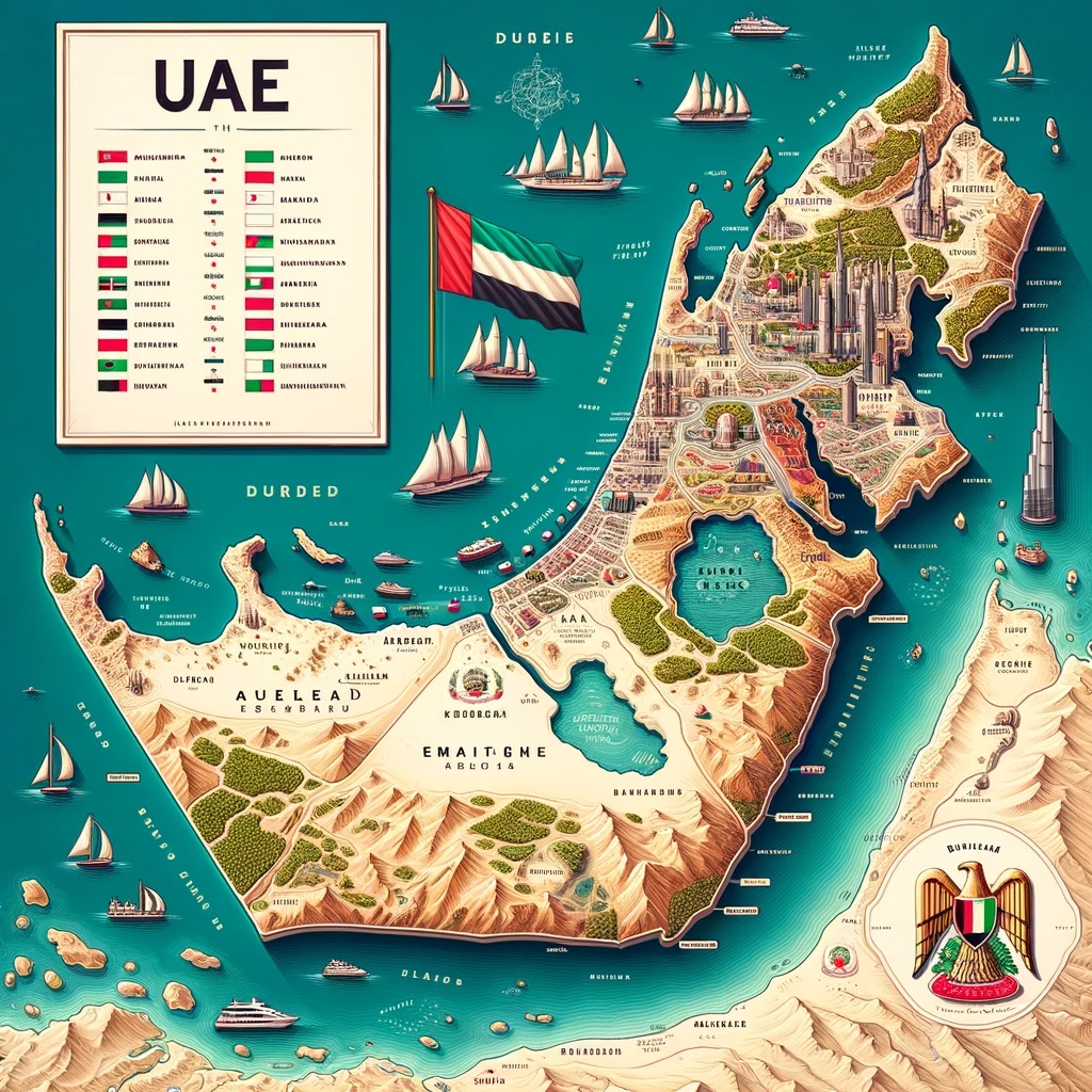
The United Arab Emirates is a coalition of seven emirates located along the eastern coast of the Arabian Peninsula. The largest among these emirates is Abu Dhabi, which accounts for over three-fourths of the total land area of the federation. It serves as the central hub for the oil sector and shares its borders with Saudi Arabia to the south and east.
Dubai, the principal city of the emirate of Dubai, is a prominent port city nestled at the base of the mountainous Musandam Peninsula. It has earned a reputation as one of the most vital economic and financial centers in the region, hosting numerous international enterprises amidst a skyline adorned with skyscrapers.
On December 2, 1971, six of the seven Arabian emirates, previously known for their historical commercial and security associations with Great Britain as the “Trucial States,” namely Abu Dhabi, Dubai, Sharjah, Fujairah, Um Al Qaiwain, and Ajman, united to establish the independent and sovereign nation of the United Arab Emirates. The seventh emirate, Ras al Khaimah, became part of the federation in February 1972.
The UAE encompasses an area of approximately 34,000 square miles, boasting a 386-mile coastline along the Arabian Gulf and the Gulf of Oman. With the exception of the oasis of Al Ain, all major towns are situated along the coast. The UAE’s landscape primarily comprises sandy deserts, salt marshes, and features a mountain range in the north, as well as scattered oases. Additionally, the UAE claims ownership of or jurisdiction over a few offshore islands.
Characteristics of Geography
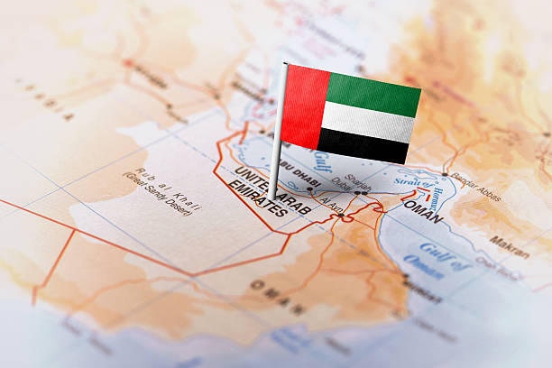
The United Arab Emirates is slightly smaller in size than Portugal, sharing its borders with Oman to the east and northeast, as well as with Saudi Arabia to the west, south, and southeast. The precise demarcation of the nation’s borders remains a subject of ongoing discussion. Its boundary with Qatar is approximately 19 kilometers (12 miles) to the northwest, while Saudi Arabia lies at a distance of 530 kilometers (330 miles) to the west, south, and southeast, and Oman is about 450 kilometers (280 miles) away to the southeast and northeast.
Abu Dhabi, the largest emirate, spans an area of 72,732 square kilometers (28,082 square miles), constituting 87 percent of the total land area of the UAE. In contrast, Ajman, the smallest emirate, covers a mere 259 square kilometers (100 square miles). The predominant landscape of the country is characterized by vast desert expanses adorned with towering sand dunes. To the east, within the Liwa oases, near Aradah, some of the world’s largest sand dunes are found. Another notable feature is the oasis city of Al-Ain, situated 100 miles (160 kilometers) east of Abu Dhabi.
The Musandam Peninsula’s eastern flank in the northern extension of the Hajar Mountains, which are shared with Oman, presents elevated terrain, reaching heights of approximately 6,500 feet (2,000 meters). Along the Persian Gulf coast, small boats can seek shelter among the islands and shoals. While naturally occurring deepwater harbors are scarce, the UAE has established significant man-made ports in Abu Dhabi, Sharjah, and Ras al-Khaimah. Additionally, Port Rashid in Dubai and the extensive Port Jebel Ali, located 20 miles (32 kilometers) southwest of Dubai City, are prominent examples. On the more conventional Gulf of Oman coastline, three natural harbors can be found in Dibba, Khor Fakkan, and Kalba.
Climate of UAE
The climate in the United Arab Emirates exhibits distinct regional variations. Along the coast, the weather is characterized by high temperatures and humidity, while further inland, it becomes even hotter but significantly drier. The average annual rainfall is meager, ranging from 4 to 6 inches (100 to 150 mm), with significant seasonal fluctuations. In January, the average temperature hovers around 64°F (18°C), but in July, it soars to an average of 91°F (33°C).
Coastal areas experience scorching summer highs that can peak at 115°F (46°C), while the desert regions can become even more sweltering, with temperatures surpassing 120°F (49°C) or more. The region is subject to the shamal, or “northerly” winds, which blow in from the north and northwest during midwinter and early summer, carrying sand and dust with them.
Flora and Fauna
Abu Dhabi’s arid climate limits the abundance of vegetation, mainly consisting of low shrubs that serve as sustenance for nomadic herds. Nonetheless, extensive afforestation efforts, particularly the planting of numerous mangroves, have created habitats for various species. Within the oases, date palms and alfalfa are cultivated, while fruit cultivation is also practiced, with the Al-Ayn oasis to the east of Abu Dhabi renowned for its mangoes. The region is home to domesticated animals such as goats, sheep, camels, cattle, and poultry, many of which were introduced more recently.
The diverse wildlife includes predators like the caracal, sand cat, Ruppell’s and red foxes, as well as larger species like the Arabian oryx and Arabian and Persian gazelles. Smaller mammals like the cape hare, lesser jerboa, and various gerbil species can also be found, along with a wide array of snakes and reptiles. The waters of the Gulf teem with schools of mackerel, grouper, tuna, porgies, and even sharks and whales.
Like Geography of UAE, You may also like to read about Living in UAE.
Drainage
The United Arab Emirates lacks perennial streams or consistent surface water sources. The ever-shifting sand dunes impede the natural drainage of the nation’s interior salt flats, known as sabkhahs, where the limited precipitation received primarily flows from the mountains through seasonal wadis. In the far west, the Ma Salt Flat extends into Saudi Arabia, while coastal sabkhahs near Abu Dhabi periodically face flooding from the waters of the Persian Gulf.
Natural Resources of the UAE
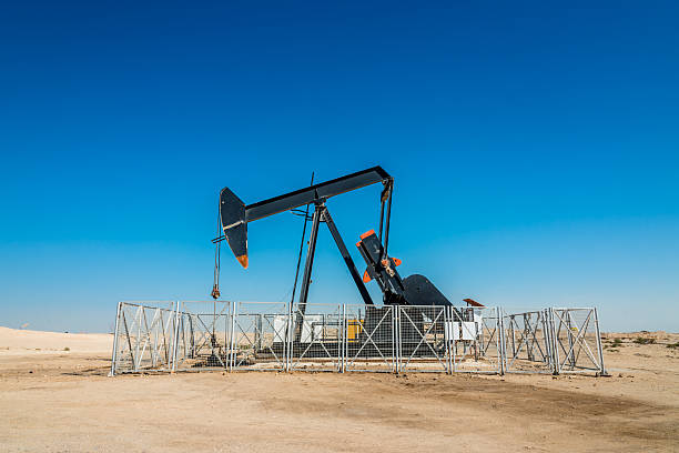
Since the discovery of oil in 1958, the government of Abu Dhabi, through the Abu Dhabi National Oil Company (ADNOC), has held the majority ownership in every oil-producing entity across the federation. Despite employing a relatively small portion of the workforce, the oil and gas industry plays a pivotal role, accounting for roughly 95% of the nation’s oil production and contributing to approximately one-third of the country’s GDP.
Notably, ADNOC subsidiary Abu Dhabi Marine Operating Company (ADMA-OPCO), in which British, French, and Japanese interests also have stakes, holds the largest petroleum concessions.
The Umm al-Shaʾif offshore field is a significant site, and the Al-Bunduq offshore field, operated by ADMA-OPCO, is shared with neighboring Qatar. In Al-Mubarraz, a Japanese consortium oversees an offshore rig, while American companies possess additional offshore concessions.
Another key ADNOC entity, the Abu Dhabi entity for Onshore Oil Operations, is partially owned by American, French, Japanese, and British interests and manages onshore oil concessions. Japanese corporations also hold various privileges in this sector.
Dubai commenced its oil production in 1969, with offshore oil fields located in Ḥaql Fatḥ, Fallah, and Rāshid. Initially, Dubai maintained control over its oil reserves, but in 2007, the emirate assumed full control of oil production. At its zenith, Dubai contributed nearly one-sixth of the nation’s total petroleum output. However, as the emirate diversified its economy, production decreased to a minimal level. In 1974, Sharjah began its oil production, and six years later, a second well was discovered, primarily producing natural gas. In 1984, oil production commenced off the coast of Ras al-Khaimah in the Persian Gulf.
The majority of the federation’s natural gas resources are concentrated in Abu Dhabi, which holds some of the world’s most substantial natural gas reserves. Starting in the late 1990s, the United Arab Emirates embarked on significant investments to expand its natural gas industry, both for export and to fuel domestic thermal power plants. Dubai and Abu Dhabi have also initiated investments in renewable energy. In 2013, Abu Dhabi constructed a 100-megawatt facility capable of powering up to 20,000 households, ranking among the world’s largest solar power plants at the time.
Wildlife in the UAE
The wildlife of the UAE encompasses a spectrum of species, ranging from domesticated animals to desert inhabitants such as Arabian oryx and gazelles, as well as the diverse marine life inhabiting the waters of the Gulf.
Geography of UAE
Geographic Location | Middle East |
Total Area | 32,278 Square Miles |
Land Area | 32,278 Square Miles |
Land Boundaries | 539 Miles |
Irrigated Land | 355 Square Miles |
Border Countries | Oman 410 km, Saudi Arabia 457 km |
Coastline | 819 Miles |
Geographic Coordinates | 24 00 N, 54 00 E |
Terrain | flat, barren coastal plain merging into rolling sand dunes of vast desert wasteland; mountains in east |
Highest Point | 1,527 Meters |
Highest Point Location | Jabal Yibir 1,527 m |
Lowest Point Location | Persian Gulf 0 m |
Natural Resources | petroleum, natural gas |
Time Zone | UTC+4 (9 hours ahead of Washington, DC during Standard Time) |
Final Thoughts
The United Arab Emirates (UAE), a union of seven emirates, is situated on the eastern coast of the Arabian Peninsula. With Abu Dhabi as its largest emirate, the UAE is renowned for its vast desert landscapes, sand dunes, and lush oases. The strategic development of major ports and thriving economic hubs, exemplified by Dubai, is a direct consequence of its extensive coastlines along the Persian Gulf and the Gulf of Oman. The region experiences seasonal shamal winds and noticeable temperature fluctuations in its arid and warm climate.
The UAE’s limited vegetation predominantly consists of shrubs and purposefully planted mangroves. The country’s diverse wildlife encompasses domesticated animals and various species, including Arabian oryx, gazelles, and marine life in the Gulf waters.
Abundant oil and gas reserves, primarily managed by state-owned entities such as the Abu Dhabi National Oil Company, underpin the nation’s economy. Furthermore, the UAE is actively investing in sustainable energy sources, notably solar power, to diversify its energy portfolio and embrace cleaner technologies.